Livestock Monitoring Helicopter Services for Rural Areas
KiliFlying Air delivers specialized livestock monitoring helicopter services for rural areas across Tanzania and East Africa, providing efficient aerial support for animal counting, health assessment, predator detection, herding assistance, and range management that enhances productivity and sustainability for pastoral communities and commercial ranches operating over vast territories.
Livestock Monitoring Helicopter Services for Rural Areas
Extensive livestock systems in East Africa cover millions of hectares where ground monitoring is labor-intensive and limited by terrain, vegetation, and seasonal accessibility. Accurate animal counts, health surveillance, and range condition assessment are essential for informed management decisions affecting herd productivity, disease control, and sustainable grazing. Helicopters offer rapid, comprehensive coverage with minimal animal disturbance, enabling herders and ranch managers to maintain oversight across dispersed grazing lands. KiliFlying Air works closely with pastoral communities, commercial ranches, veterinary services, and conservation programs to deliver tailored aerial monitoring that supports both traditional livelihoods and modern livestock enterprises.
Our livestock monitoring flights combine experienced observers familiar with local breeds and conditions with high-resolution imaging to produce detailed reports on animal distribution, body condition, calf ratios, and environmental impacts. Operations prioritize animal welfare through established low-stress protocols developed in collaboration with veterinary experts.
Animal Counting & Population Surveys
Precise herd inventories guide stocking rates, marketing decisions, and insurance valuations. Systematic helicopter surveys count cattle, sheep, goats, and camels across vast rangelands where ground counting is impractical, providing statistically robust estimates with species and age class breakdown.
Calf/cow ratios indicate reproductive success while sex ratios inform herd management. Seasonal surveys track migration patterns between wet and dry season grazing areas, supporting community agreements on resource sharing.
Health & Condition Assessment
Early detection of health issues prevents widespread losses. Aerial observers identify animals showing poor body condition, lameness, skin lesions, or respiratory distress indicative of disease outbreaks.
Targeted low passes allow detailed examination of suspect individuals for GPS marking and ground team follow-up. Regular monitoring supports vaccination campaign planning and rapid response to notifiable diseases like foot-and-mouth or rift valley fever.
Predator Detection & Human-Wildlife Conflict Monitoring
Predator-livestock conflict threatens pastoral livelihoods near protected areas. Helicopter patrols locate lion, hyena, or leopard signs around herds, enabling preventive herder deployment or problem animal response.
Thermal imaging supports night operations while documenting conflict incidents provides evidence for compensation claims and conservation planning. Interface monitoring between wildlife corridors and grazing lands informs coexistence strategies.
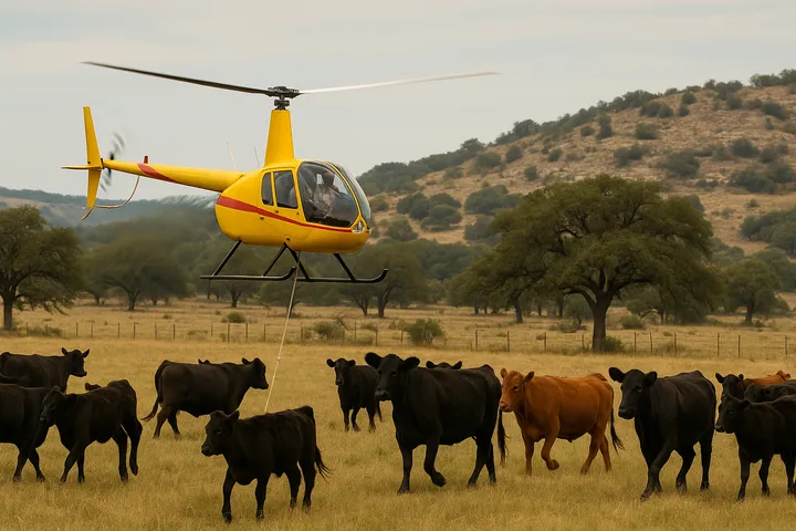
Herding Assistance & Mustering Support
Gathering dispersed animals for dipping, vaccination, or market preparation benefits from aerial herding. Helicopters gently direct herds toward collection points across difficult terrain, reducing labor requirements and animal stress compared to ground mustering.
Water point location flights guide herds during drought periods while emergency mustering supports rapid evacuation from flood-prone areas or fire threats.
Range Condition & Grazing Management
Sustainable grazing requires monitoring vegetation cover and soil condition across seasonal ranges. Aerial surveys assess grass biomass, bare ground extent, and bush encroachment that reduce carrying capacity.
Mapping water point functionality and herd concentration areas supports rotational grazing plans. Long-term monitoring documents rangeland recovery under community management programs.
Technical Capabilities & Monitoring Methods
Our livestock monitoring helicopters support comprehensive assessment:
- Experienced local breed observers
- High-resolution imaging for individual identification
- Thermal imaging for night/location work
- GPS-marked animal and hotspot reporting
- Low-stress flight protocols
- Systematic transect methodology
- Collaboration with community scouts
Reports include animal distribution maps, condition scores, management recommendations, and photographic documentation.
Frequently Asked Questions
Livestock monitoring helicopter services from KiliFlying Air support sustainable rural livestock management with efficient aerial oversight. Protect and optimize your herds with professional monitoring. Explore our Wildlife Tracking and Environmental Monitoring for related capabilities.